Near the Little Patuxent River
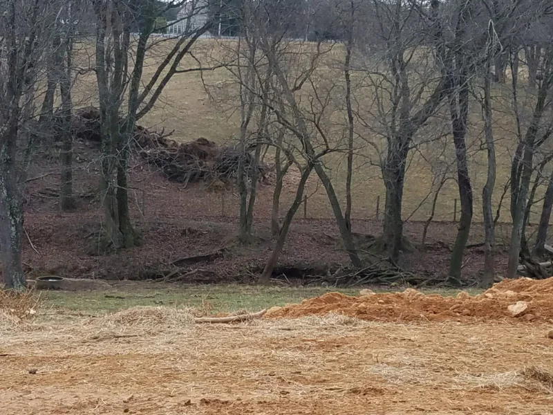
On a recent morning – I headed out to the stream that flows under Broken Land Parkway from Lake Elkhorn just before it joins the Little Patuxent River for a volunteer gig – guiding a stream survey done by high school students. Near the bridge that crosses the stream on the Patuxent Branch Trail, there was muddy trail (poison ivy on each side…glad I had on long pants and high boots) to allow access down to stream. We set up our gear around three tables. There was not much dry area to set them up but the water was shallow. A partner and I guided 10 students to collect and ID macroinvertebrates from one of the tables while other volunteers did the same at two others. We had about 45 minutes….and then we got another group of 10 to do it again.

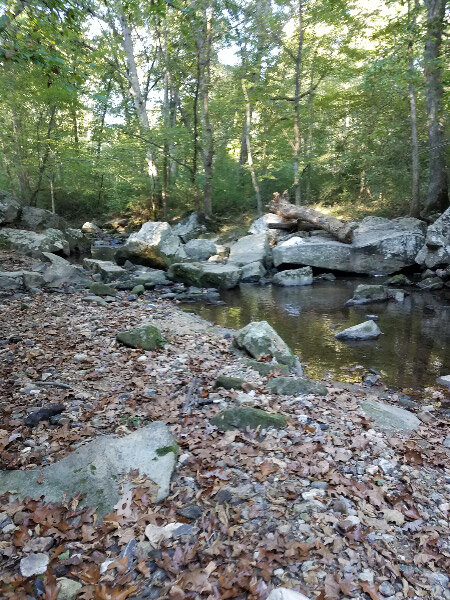
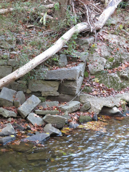
I took some pictures before and after the students arrived. The steam has a lot of vegetation on the banks but the stream has been eroded  - with some trees toppling over from being undercut by rapidly moving water. It is in an area where there is a lot of impervious surface. When it rains – the water rushes down to the stream where it carries away anything in the eroded channel; there is no connection to a flood plain that to slow down the water. It doesn’t take long for it to run off further downstream because we are in the Pediment rather than the Coastal Plain (i.e. there is always an incline for the water to follow).

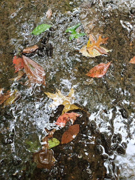
The water quality was ‘very poor’ based on the types of macroinvertebrates that we found…however – we found quite a few of the types we found. The stream is not dead. Life holds on tight in this suburban stream.

Patuxent River

My husband and I enjoyed the PAXCON Reflections (the webinars provided in lieu of the Patuxent River Conference this year). The recordings are now posted to the website (link above) and available to all. The topics include:

How climate is changing in the Chesapeake Bay region and the Patuxent River watershed, potential impacts to Patuxent River water quality, and how communities can prepare for the future

The importance of wetlands in the Chesapeake Bay Region

Stormwater and how local communities are working to restore their streams and meet regulatory requirements

I’ve been prompted by these webinars to think about my own connection to the Patuxent River close to where I live. The Middle Patuxent originates in Howard County and joins the Little Patuxent near Savage, MD which continues southeast to join the Patuxent River just before it crosses under Crain Highway just south of Crofton, MD. There are 5 locations where I’ve been at or in the Middle Patuxent in recent years. The first 4 are sites for volunteer gigs (pre-pandemic) with high school students assessing water quality. Use the Google Map starting at MPEA and follow the Middle Patuxent.

MPEA

Middle Patuxent Environmental Area is near the origin of the Middle Patuxent. There are several streams that come together in the area to form the river. A loop of the Southwind Trail that goes close to the river. There are a lot of rocks in and along the river…riffles and runs and pools…places for lots of critters.

One time I went down when it was raining – the trail too muddy and the river too high for the water quality sampling. The runoff water had some foam in it and the speed of the water demonstrated how the banks eroded with each such event (note the leaning tree at the edge of the water.)

Robinson Nature Center

Robinson Nature Center is a little further down river from MPEA. I did water quality monitoring with other adults at that location pre-pandemic. There is more water in the channel than at MPEA. The trees along the river are smaller and don’t shade the water…making the water warmer that it was prior to the surrounding development. The banks are somewhat incised but there are still some beach areas…riffles, pools, and runs. There is more silt as well. There are still a few big rocks in the river. Note the whale shaped rock!

Edenbrook

The Middle Patuxent flows under Columbia Pike and on through suburbia. Parking at the dead end of Edenbrook Drive near Kings Contrivance and walking down the old road (gated) to the river is another access point. There use to be a bridge over the river that connected to Kindler Road on the south side. It washed away years ago, but the abutments are still along the river. The banks are more incised. The river is disconnected from its flood plain by this point (it has cut a deep enough channel that it doesn’t broaden much even when there is a lot of water: the water just flows faster and the channel just gets deeper).

Sweet Hours Way

2019 10 IMG_5783.jpg

Parking on Sweet Hours Way and taking the Kings Contrivance Loop trail down to the rive is a little scenic hike on a paved. The banks are much more heavily incised here. The paths from the trail down to the river bed are very steep. There are trees that lean over the river in some places but some of them are barely attached to the bank. Once they fall, the stabilization they provided will be gone and the bank will collapse…until another tree’s roots hold the soil.

There are stretches of the river here that are sand/silt; the rocky bottom has been covered over.

20181015_082352.jpg
20181015_101101.jpg

The little streams that flow down to the river here are also incising their banks. The land is sloped, and the banks quickly erode when they don’t support enough vegetation.

Behind my house

I hiked down to Middle Patuxent behind my house last spring during the first wave of the pandemic. Trees have fallen into the river – probably during a wind/rain event. They were big enough that they would have been growing at the river’s edge when my daughter was young (over 20 years ago) and we tried to make boats from sycamore bark on one trip to the river. During big rains, the water accumulates and runs off more rapidly now than it did then. There is forest buffer along the river but there has been a lot of development (impervious surface) in the watershed between MPEA and my neighborhood.  Some development is much closer to the river than my neighborhood with is about 0.13 miles from the river (forested). Some roads closely parallel the riverbed.   

I don’t know the river beyond that point although I might decide to take a small field trip to the Savage Mill/Bollman Iron Truss Bridge to look at the area where the Middle Patuxent merges with the Little Patuxent. I walked in the area years ago…but it was before I started taking pictures.

Ten Little Celebrations – September 2019

September was a transition month…the end of the Wings of Fancy exhibit and the gearing up for the Howard County Conservancy’s fall field trips for county schools. That overall theme carried over to almost all the little celebrations I’m featuring in this month’s post.

Beginning yoga. I was surprised that I could do some of the poses with relative ease….and others with a little practice. It’s surprising how quickly the benefits begin to be noticeable.

2019 09 IMG_5403.jpg

Question Mark Butterfly. I was thrilled to notice the butterfly in the mulch at Brookside Gardens when its wings were open. I would have never seen it had its wings been closed. I celebrated a second time after I got home and figured out what kind of butterfly it was.

2019 09 IMG_5605.jpg

Mount Vernon. What a place for a volunteer appreciation day…and the weather was perfect! I celebrated the place and the people I was meeting all day long.

Longwood Gardens. The place is always special – because of what we see there during our visit and the memories of other visits.

2019 09 IMG_0213.jpg

Toad near the stream. There are always those serendipity events that make an ordinary hike extraordinary.  During one of our training sessions at Belmont we hiked to the small stream….and were finding mushrooms and moss and macroinvertebrates….and then a small toad jumped into our midst! Being naturalists…we all celebrated.

Large monarch caterpillar. My milkweed didn’t have many caterpillars this year…but one morning when I looked there was a large one (obviously had been there eating). I celebrated that he was probably big enough to make a chrysalis.

Casemaker caddisfly. We’ve had almost no rain for the past month or so and the stream was low…but we found several casemaker caddisfly larvae! They looked like a small clump of debris at first….and then they moved. It’s good to see living things in the water even when there is not much water around.

Carrot cake. I was celebrating something but the carrot cake itself overwhelmed whatever I was celebrating. Yummy!

m 2019 09 IMG_5479.jpg

Wings of Fancy. The next to the last volunteer shift in the Wings of Fancy exhibit was a light day for visitors and I celebrated some quiet time with the butterflies.

Day at Little Patuxent River. High schoolers in the river….interested and focused. The water was low but they found some macroinvertebrates and they were so organized in the chemical tests of water quality (my station for this field trip) that we finished everything with a little time to spare. Celebrating high schoolers!

Patuxent Branch Trail

Sometimes volunteer activities help us find something new close to where we live. That happened to my husband and I recently. I had volunteered us to count pedestrian and bike traffic as a trail near where we live for a community organization. The location on the Patuxent Branch Trail was only about 3 miles from hour house….and I’d never been there before.

The trail crossed the Little Patuxent River on a re-purposed railroad bridge built in 1902 – the year after one of my grandfathers was born! It became a pedestrian bridge in 2002.

20180609_111937 resize.jpg

The bridge was still full of sediment from recent rain. Both pictures below taken from the bridge. I was not surprised at how many people (pedestrian and bicyclists) stopped on the bridge to enjoy the view.

My husband is already talking about biking the trail on the next day without rain in the forecast!

HoLLIE – Week 6

The Week 6 of HoLLIE (Howard County Legacy Leadership Institute for the Environment) class focused on The Chesapeake Bay Watershed and Environmental Advocacy. As my norm, I arrived early so I could enjoy the sunny (but cold) morning at Belmont before the before class. I stopped at one of the pullout spaces on the narrow drive to photograph the stumps from the recent tree removals (and there are more to come). The first picture is looking away from the Manor House; the second shows the Manor House in the distance.

I took pictures of the two stumps from the trees already cut down. Someone had carved in one of them. Aargh! It’s sad when a tree is cut down and the carving struck me as disrespectful to the tree and the place.

After I got to settled into my place in the carriage house, I trooped over the butterfly meadow where I saw the bright yellow grass late last week. It was still there, and I liked the snow and blocks in the picture with it.

2018 03 IMG_9039.jpg

The little walks outside were a good start to the day that was sedentary otherwise. Our speakers were from the Chesapeake Bay Foundation, Land Trust Alliance (re the Chesapeake Bay), and Patuxent River Riverkeeper in the morning. In the afternoon we heard about sustainability and what individuals in our area can do toward the goal of moving toward sustainable lifestyle…and beyond to regenerative. The last segment of the day was a short lecture on effective environmental advocacy that included a practice use of the planning template from the lecture….learning enhanced by attempting to apply the technique.

Next week we’ll be outdoors in the last segment of the day. I’m already watching the forecast for the day; as of now – the forecast is cold and a bit breezy…but no rain.

Previous HoLLIE posts: Week 1, Week 2, week 3, week 4, week 5

Monitoring Conservation Easements

This December is my first experience volunteering to do the annual monitoring of conservation easements for the Howard County Conservancy. I went to a training back in September and then ‘shadowed’ an experienced monitor visiting 2 easements in November. In December, I was ready to monitor 2 easements with a cohort that was doing it for the first time as well.  The owners were notified by Howard County Conservancy that we would be monitoring on a particular day and the weather cooperated for both days – dry and not overly cold. The first property was mostly forest and the hike around the property was different than my usual hike since there were no well-defined trails; deer trails or picking a path through the briars (glad we were doing this in December when it was cold enough to wear heavy pants to protect my legs from thorns). It was a wonderful early winter ‘walk in the woods.’

The land was crossed by a stream that feeds into the Patuxent River. We had one stream crossing over a culvert but made another stepping on rocks; it was good that it had not rained recently. Most of the trees were native…but there was a substantial clump of bamboo growing on one streambank.

The land was easier to see with the leaves on the ground. As usual, I noticed fungi.

There was an odd holly-like plant as part of the understory. The leaves looked like holly but the top did not.

20171205_112732.jpg

At the end of the walk, I rejoiced that the property owner had made the effort to make it a conservation easement and that it was about that same as it had been in previous years.

The second easement was entirely different: surrounded by housing developments and an active farm/golf related business rather than forest. The business was about the same as it had been in the previous year…but there was a change at the farm: a guard dog. The dog did not appear immediately, but no one was home. We could tell that there had been some earth moving going on upslope from the stream that starts on the farm and eventually flows into the Patuxent River. If a heavy rain came – a lot of soil would slump down into the stream. The dog appeared…and we decided to gracefully retreat without completing our check of the easement. The monitoring will have to be done when the owner or their representative can be there. It was a rattling experience, but we enjoyed a hefty morning snack with hot tea/latte to recover!

20171212_102317.jpg